
Tags
Cass Scenic Railroad, Fall leaves, Green Bank Observatory, motorcycle travel, Shay steam engines
An unlikely assemblage of vehicles, some with two wheels, three, and some with four, departed Blacksburg on a foggy morning an hour before sunrise, their drivers and passengers looking for open-air adventure in West Virginia. There were three BMW motorcycles, one Honda Goldwing, one Suzuki V-Strom, two Can-Am Spyders, a Honda trike, a Miata convertible, and a 3-series BMW. After an hour chasing taillights through 50-degree air and patchy fog, our gaggle arrived at our first stop. The fog had not lifted, but a bit of daylight illuminated the parking lot and the aroma of coffee showed the way to the Kalico Kitchen in Union, WV. The eclectic combination of vehicles carrying us eight men and six women suggested a group with dissimilar backgrounds and tastes, but our “older age” pre-disposed us to a lot of common conversation over the breakfast table: travel, family, friends, aches and pains, and our passion for riding motorcycles. This trip was about all those things.

Breakfast at Kalico Kitchen, Union, WV. Nancy, Don, Jim, Genevieve, Mike, Bob, Jim, Brian, Joan, Jeff, Cathy, Mae, Cecil.
On November 6, 1863, during the American Civil War, Confederate forces engaged Union forces on Droop Mountain West Virginia. The Confederates failed to prevent Union forces from a rendezvous with other Federal troops in a joint raid on Confederate railways. It was one of the largest battles in WV, but the Confederate loss pretty much ended Federal resistance in the state. The battlefield is now a lovely West Virginia State Park with an iconic observation tower with views across valleys and mountains. We were looking forward to those views as Mike led us the “long way” through the Park. But, alas, views were not to be had. I heard words including zero visibility, fog, pea soup, murk, smaze—you get the picture. There were also doom and gloom comments about the likelihood of more of the same at our next stop.

Foggy at Droop Mountain Battlefield State Park.

Cecil and Mae in the observation tower at Droop Mountain State Park.
The Highland Scenic Highway traverses the mountainous terrain of the Allegheny Highlands and Plateau. It rises from Mill Point at 2,200 feet to over 4,500 feet along the Parkway. On the south end is Cranberry Mountain Nature Center, one of best presentations of all facets of WV’s natural ecosystems including a live snake display, native plant garden, and an illustration of life in wild cranberry bogs. As we climbed Cranberry Mountain on Route 39 toward the Nature Center, we broke out of the fog layer into the brilliant sunshine that shone on a palette of color that was the mixed deciduous forest: standing out were brilliant red maples, golden hickories, magenta black gums, and brown/yellow speckled American beech.

The beginning of the Highland Scenic Highway in front of the Cranberry Mtn Nature Center
We were ten days past peak color season, but the 40-mile ride on the Parkway did not disappoint. From Big Spruce overlook a forest-type elevational gradient was still obvious beginning with red spruce at the tops of the highest peaks, followed below by the northern hardwood forest of yellow birch, beech, and sugar maple, followed by mixed mesophytic black cherry, northern red oak, and tulip poplar, and, finally, white, scarlet, and chestnut oaks on the lower, drier ridges. These forests are second and third growth forests that regenerated naturally after the virgin timber was clearcut. Fierce fires consumed the harvest slash and debris as well as the deep, organic soils that nourished the virgin tree stands. Close inspection of the vegetation on the mountain tops along the Parkway reveals a new forest, a mere shadow of its former self, growing in a few inches of soil among jagged boulders. The story of what once was, and what is left, on these mountains, awaited us at Cass, WV, a company timber town, where we would spend the night.
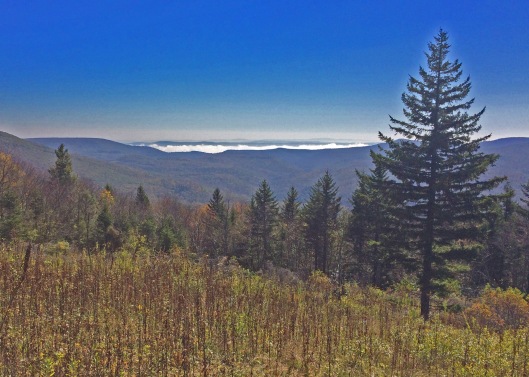
Big Spruce Overlook on the Highlands Scenic Highway, WV
From Slatyfork, WV, we rode east on the Snowshoe-Cass-Greenbank Rd. Tucked away in a valley between Marlin Mountain and Buffalo Ridge is the village of Green Bank. Its claim to fame is that it is located within the National Radio Quiet Zone, which means that radio transmissions are restricted by law. That means no cell phones, among other electronic devices! Green Bank’s population has up-ticked a bit as some folks believe they suffer from electromagnetic hypersensitivity. It’s a nice little village, but escape from cellular radiation is the main attraction, and these folks are secure in their homes and about town by “radio policeman” who use specialized equipment to detect signals from unauthorized electronics.

World’s largest movable radio telescope at the National Radio Astronomy Observatory in Green Bank, West Virginia (This is as close as one can get with a digital camera).
Of course, Green Bank’s real claim to fame is the National Radio Astronomy Observatory, which operates the world’s largest, movable radio telescope, the reason for the “Quiet Zone.” Standing 485-feet tall, with a dish surface area of 3.5 acres, the telescope could contain a college football stadium. As was explained on our group tour, its purpose is to study the natural radio emissions that are coming from bodies in space as far away as 13 billion light years. Many thanks to Bob, one of our gang, who knew Frank, a recently retired Observatory scientist, we received an extensive tour of the facility, including the control room, a Faraday cage, where the radio signals are collected and interpreted.
Departing Green Bank I turned my cell phone back on and placed it back in my shirt pocket above my beating heart where it usually resides. On the ride back to Cass, I wondered about symptoms of electromagnetism. My pulse has been normal and I still have a pretty good head of hair, but I will remain vigilant—besides, Green Bank appeals to me.
Cass, WV, was founded in 1901 by the West Virginia Pulp and Paper Company (WVP&P) to serve the needs of the men who worked in the Cheat Mountain area cutting the virgin forests. To extract the timber, the company built a track from the floodplain of the Greenbrier River to the top of Bald Knob, the third highest peak in WV. WVP&P was originally only interested in the red spruce growing at the highest elevations, but soon realized the wealth residing in the oak, cherry, maple, and birch on the mountain slopes.
“Cheat Mountain is truly a mighty mountain. It is rough and cold. It bore upon its top and sides one of the greatest and richest loads of timber to be found anywhere.” —W. E. Blackhurst

Second-growth forest on the south end of Cheat Mountain. Red spruce is visible on the top of the ridge with cherry, maple and red oak below.
So, the company built the town of Cass including houses, company store, school, churches, and clinics and proceeded to cut timber with a vengeance. Tumult on the Mountains is the name of Roy B. Clarkson’s book that portrays the lumber industry in WV from its inconspicuous beginnings through a century of progress. He describes the day-to-day work and life of the men engaged in the felling, skidding, hauling and sawing of timber.
Then, suddenly, in a few short decades, it was all cut out. Left for Mother Nature to redeem was an ugly landscape of stumps, slash, brush, eroded hillsides, silted streams and rivers, and burnt over mountainsides. The timber played out around 1960 and in 1977 the Cass Scenic Railroad State Park took possession of the entire company town.

Row houses for workers in the sawmill town of Cass, WV, now available to tourists. Our group occupied two houses for our Saturday night stay.
Our group occupied two of the old company houses that Saturday night. I inspected the house and walked around the camp looking for any evidence of the men and women who occupied this place during the first half of the 20th century. The transition of Cass to a tourist destination with an emphasis on old steam trains is pretty much complete, but having spent time in the museum studying the wealth of old photos, and having read W.E. Blackhurst’s book “Of Men and a Mighty Mountain” I could conjure up some images of who they might have been.
“To harvest that great crop, it was the task of toughened men to perform the feats of labor required there. Men of reckless daring were needed to push smoke-belching engines up and down the steep slopes. Three thousand men at one time concentrated their efforts and their widely different skills in the massive assault against the mountain.” —W. E. Blackhurst
At 8 am Sunday morning, desperate for a cup of coffee, we found it and breakfast at the Cass General Store just across the Greenbrier River. Before our train ride we had time to visit the museum, gift shop and old post office. On schedule, Shay No. 2 lumbered down the track to the depot pulling five open excursion cars for our 11 am departure for Whittaker Station four miles up the mountain.

Cass is home to the world’s largest fleet of geared Shay locomotives. There are six that are operational at Cass. Shay engines are special, unlike other locomotives, due to their power, slow speed, and ability to traverse grades as steep as 10%. Their boilers were offset to the left to counterbalance the weight of a three-cylinder steam engine mounted vertically on the right with a longitudinal drive shaft extending fore and aft from the crankshaft at wheel axle height. Each wheel axle was driven by a separate bevel gear (90 degree) from the crankshaft. The strength of these engines is that all wheels, including those under the tender, are driven for maximum tractive effort.
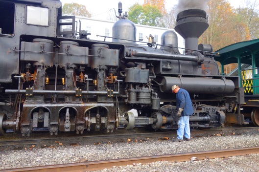
The Shay engine being oiled before its trip up the mountain. Note the three vertical cylinders and the crankshaft that drives all wheels under the engine and its tender.
Our gang mounted car B, the second behind the Shay. An ear-piercing whistle signaled our departure up and along Leatherback Creek past the ruins of the old sawmill, foundry, and maintenance shop. Within four miles, the train climbed from 2,443 feet at Cass to 3.264 feet at Whittaker Station, our destination. The last half mile rose at a 9% grade; the Shay really “hammered” and spewed a plume of dense black smoke and cinders all the way.

The Shay engine pulling its train up a 9% grade, and spewing cinders on the big head of the fellow on the right of the photo!
After a 30-minute respite at Whittaker Station, we returned with less attention on the train and more on the beautiful landscape around us. As we descended down the mountain through the hardwood forest I marveled at the already large size of the black cherry, red oak, and sugar maple trees given that they were less than 80 years old. They had recaptured the canopy from early successional species; after another century there will be some semblance of the original forest, but, sadly, sans the American chestnut.

View on the descent down the mountain from Whitaker Station.
Shortly after Shay #2 pulled back into the station, I left my riding buddies behind for a solo ride home. I took the long way in order to visit the New River Gorge. The New River is not new. It is older than the Appalachian Mountains themselves. This part of the river was inaccessible to most people until 1883 when the railroad opened it to the outside world. Mining boomed and towns like Thurmond sprang up overnight near the coalfields. And suddenly the coal under the mountains, like the virgin timber on the mountains, was gone. Boom and bust; I guess the gas fields will be next.

The New River Gorge north of Hinton, West Virginia.

Maples dropping leaves like yellow confetti.
I stopped at the National River Visitor Center at Sandstone then followed the river on the edge of the gorge to Hinton at the confluence of the New and Greenbrier Rivers. It was a quiet Sunday afternoon. The landscape along route 12 between Hinton and Peterstown was awash with evening light. Where the road passed through the forest, maple trees were dropping leaves that fluttered past my windscreen like yellow confetti. I reflected on the weekend and thought about my riding buddies and the great time I had with all. Mike did a wonderful job organizing this action-packed two-day event. Many thanks to him, Cecil and Bob who made it all possible.
Read additional motorcycle travel adventures here: https://boxxersblog.com/category/motorcycle-diaries/

Wow, really enjoyed your narrative!
LikeLike
Reading about the regrowth of the forests made me think of the progress White Oaks has made in the past 20 years. Can you believe it’s been that long??
LikeLike
I’ve watched your forest grow more beautiful every year!
LikeLike
Jim, Another great piece from you, we very much enjoyed reading it, particularly about the forestry. Is the majority of the regrowth natural or planted?
LikeLike